


Lozère j 4

rigol05
User
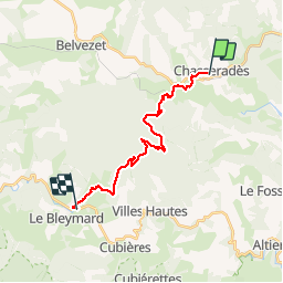

Length
17.9 km

Max alt
1413 m

Uphill gradient
527 m
Km-Effort
25 km

Min alt
1071 m

Downhill gradient
615 m
Boucle
No
Creation date :
2015-07-05 00:00:00.0
Updated on :
2015-07-05 00:00:00.0
5h16
Difficulty : Medium

FREE GPS app for hiking
 SityTrail
IGN / Geographical institutes
SityTrail Plus
The world is yours!
About
Trail Walking of 17.9 km to be discovered at Occitania, Lozère, Mont Lozère et Goulet. This trail is proposed by rigol05.
Description
Etape Chasseradès le Bleymard.Beaucoup de route et de piste rendant le parcours un peu lassant
Positioning
Country:
France
Region :
Occitania
Department/Province :
Lozère
Municipality :
Mont Lozère et Goulet
Location:
Unknown
Start:(Dec)
Start:(UTM)
565596 ; 4933331 (31T) N.
Comments